Read the scale
Find the ratio or scale bar for the actual map you are using. Check whether it has been resized or zoomed.
Keep the units the same, convert the result, then check whether the map has changed size.
Use the free template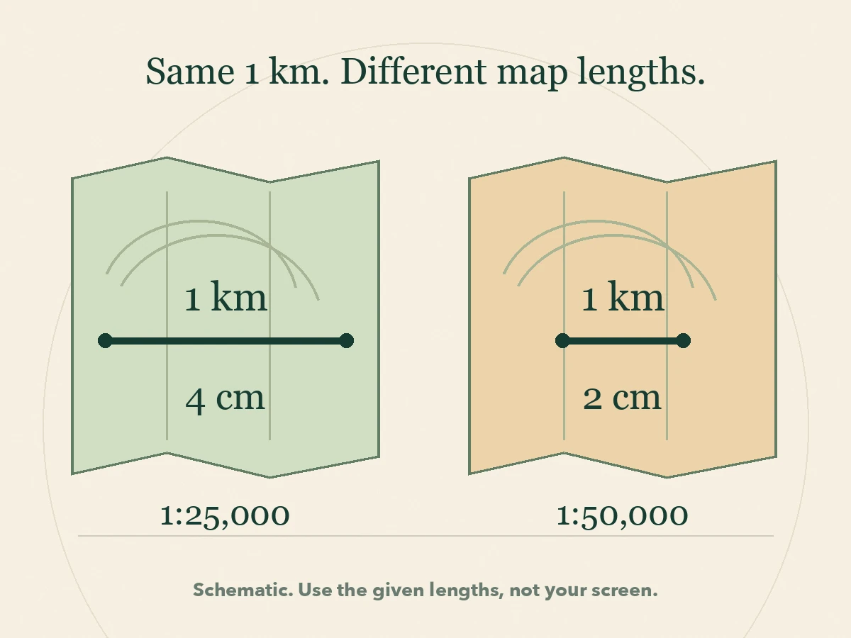
A ratio such as 1:25,000 is a relationship between lengths. It does not mean that every map square is 25,000 meters wide, or that the number after the colon is already in kilometers.
These original fictional measurements let you practice the calculation without a map, an app or an account. They assume a consistent local scale. Do not measure the illustration on your screen: its displayed size changes with your device.
The short answer
At 1:25,000, 1 cm on the map represents 25,000 cm on the ground, which is 250 m. Multiply a map distance in centimeters by 250 to get meters. At 1:50,000, multiply by 500 instead. If a map has been enlarged or reduced, use a scale bar resized with the map, rather than trusting its old printed ratio.
The method
Write the unit beside each number so the conversion stays visible.
Find the ratio or scale bar for the actual map you are using. Check whether it has been resized or zoomed.
For 1:25,000, multiply centimeters on the map by 25,000 to get centimeters on the ground. The ratio itself does not change the unit.
There are 100 cm in 1 m and 1,000 m in 1 km. Divide ground centimeters by 100 for meters, or by 100,000 for kilometers.
Convert the ground distance back to the original unit and divide by the ratio denominator. You should recover your map measurement.
Suppose the straight line between two places measures 6.4 cm on an unchanged 1:25,000 map. Start with the units: 6.4 cm × 25,000 = 160,000 cm on the ground.
Divide by 100: 160,000 cm is 1,600 m. Divide by 1,000 again: that is 1.6 km. You can also use 250 m per map centimeter: 6.4 × 250 = 1,600 m.
Reverse check: 1.6 km is 160,000 cm. Dividing by 25,000 gives 6.4 cm, the original measurement. If you got 160 km, the reverse check would expose the unit error.
Ordnance Survey explains the same-unit ratio and shows that 4 cm at 1:25,000 represents 1 km. Our numbers are invented practice, not a measured journey.
Think of each ratio as a fraction: 1/25,000 is twice 1/50,000. A feature takes up twice the map length at 1:25,000. The larger denominator makes the feature smaller on the map, not larger.
For the same 1 km ground distance, convert to 100,000 cm. At 1:25,000 it occupies 100,000 ÷ 25,000 = 4 cm. At 1:50,000 it occupies 2 cm. The ground distance has not changed.
Conversely, the same 4 cm measured on those two maps represents different distances: 1 km at 1:25,000 and 2 km at 1:50,000. Copying a ruler measurement from one scale to another does not preserve the ground distance.
Larger-scale maps can show smaller features, while a smaller scale can fit more ground on the same sheet. USGS describes this tradeoff in representing real features on paper. Scale alone does not establish that a particular map is current or complete.
A scale bar is a drawn length labeled with the ground distance it represents. Suppose a bar labeled 1 km measures 2 cm on your copy. A straight route measures 5 cm. The route is 5 ÷ 2 = 2.5 bar lengths, so it represents 2.5 km.
Use the bar's labeled interval, not an unlabeled margin or the whole row of numbers. A bar split into two segments of 500 m has a total labeled length of 1 km. One segment and the whole bar represent different distances.
The comparison works with any common measuring unit: centimeters, millimeters or another consistent length. The useful calculation is route length divided by bar length, multiplied by the ground distance stated on that bar.
Return to the 1:50,000 copy whose 1 km bar measures 2 cm and whose route measures 5 cm. Now enlarge the whole map uniformly to twice its original width and height. The route becomes 10 cm long, and the same 1 km bar becomes 4 cm long.
The bar comparison still gives 10 ÷ 4 × 1 km = 2.5 km. But treating the enlarged copy as 1:50,000 gives 10 × 500 m = 5 km, twice the correct answer. Its effective ratio is now 1:25,000, although the old printed text still says 1:50,000.
This works only if the bar and map are resized together by the same factor. A separately pasted bar, stretched image or cropped-out scale cannot establish the new distance. On a digital map, use the scale indicator for the current view. Do not assume a screenshot preserves the scale of an earlier zoom level.
In an invented park diagram at 1:25,000, the straight line from the gate to a pond is 2.8 cm, representing 700 m. The path bends. Measuring along its three sections gives 1.2 cm + 0.8 cm + 1.6 cm = 3.6 cm, representing 900 m.
Both calculations can be correct because they answer different questions. A ruler across the endpoints measures the straight line. To approximate a curved path on a physical map, follow its bends with small measured sections or a flexible piece of string, then compare the resulting length with the scale.
These examples concern horizontal map distance. They do not establish walking time, access, steepness, safety or the exact distance traveled over uneven ground. Use suitable current maps and navigation guidance for an actual outing. This worksheet is arithmetic practice, not a navigation qualification.
1. A line is 7.2 cm long on an unchanged 1:10,000 map. How many meters does it represent? 2. A scale bar labeled 500 m measures 2 cm; a route measures 8 cm. What is its distance? 3. A 900 m distance appears on maps at 1:20,000 and 1:50,000. Which drawing is longer, and by how much?
Check 1: one map centimeter represents 100 m, so 7.2 cm represents 720 m. Check 2: 8 ÷ 2 = 4 bar lengths; 4 × 500 m = 2,000 m, or 2 km.
Check 3: 900 m is 90,000 cm. Dividing by 20,000 gives 4.5 cm; dividing by 50,000 gives 1.8 cm. The 1:20,000 drawing is 2.7 cm longer. Both represent the same ground distance.
If you want more practice with ratios, units or reading maps, try Cadence. We make the app. Describe what you want to understand and answer the setup questions to build a course around your starting point.
The suggested goals below are starting points you can adapt, not a promise of a fixed map-reading course. Cadence is not a live map, route planner or substitute for practical navigation training. The examples and worksheet here are complete without the app.
Free practice worksheet
Keep the units visible, check the scale and reverse your answer.
Download worksheet (.txt)MAP-SCALE PRACTICE WORKSHEET Learning Cadence | Original fictional examples | November 7, 2026 MY DISTANCE CHECK Map and date: What am I measuring: a straight line or a route? Ratio or labeled scale-bar interval: Has the map been resized or zoomed? Map measurement and unit: Ground distance in the same unit: Conversion to meters or kilometers: Reverse check: What the distance cannot tell me: TRY BEFORE CHECKING 1. At 1:10,000, a line measures 7.2 cm. Find its ground distance in meters. 2. A bar labeled 500 m measures 2 cm. A route measures 8 cm. Find its distance. 3. A 900 m distance appears at 1:20,000 and 1:50,000. Find both map lengths and their difference. 4. An original 1:50,000 map has a 1 km bar measuring 2 cm and a route measuring 5 cm. Enlarge both lengths twofold. Calculate with the resized bar, then explain why the old ratio gives the wrong answer. ANSWERS 1. 7.2 x 10,000 = 72,000 cm = 720 m. Reverse: 72,000 / 10,000 = 7.2 cm. 2. 8 / 2 x 500 = 2,000 m = 2 km. 3. 900 m = 90,000 cm. 90,000 / 20,000 = 4.5 cm; 90,000 / 50,000 = 1.8 cm. Difference 2.7 cm. The ground distance is unchanged. 4. The new bar measures 4 cm and the route 10 cm. 10 / 4 x 1 km = 2.5 km. Using the old ratio gives 10 x 500 m = 5 km, twice the correct distance. The effective new ratio is 1:25,000. The bar and map must be resized uniformly together. There are 100 cm in 1 m and 100,000 cm in 1 km. A ratio compares the same unit on both sides. Do not measure the website illustration on your screen. These fictional calculations do not establish route access, walking time, safety or practical navigation competence.
Put it into practice
If you want more practice with ratios, units or maps, try Cadence. Describe your learning goal and answer the setup questions to build your course. Cadence is our app.


Want new features first?
Questions
One unit on the map represents 25,000 of the same unit on the ground. One centimeter represents 25,000 centimeters, or 250 meters.
Multiply the map centimeters by the ratio denominator, then divide by 100,000. For example, 6.4 × 25,000 ÷ 100,000 = 1.6 km.
Only if the ratio still matches its actual size. After uniform resizing, a scale bar resized together with the map preserves their length comparison. An old printed ratio does not update itself.
No. It uses fictional given measurements to practice ratios and unit conversion. Real navigation also needs suitable current maps, route information and practical skills.
See it in concrete terms
Adapt a suggested learning goal to the question you want to answer.
Rebuild your math from what you actually use.
Do the sums in your head before anyone reaches for a phone.
Understand why countries and borders are where they are.
Method
Original distance calculations, a twofold resizing counterexample and fresh transfer questions teach ratio and unit checks rather than a memorized answer.
What we checked directly: On November 7, 2026 we read Ordnance Survey's scale explanation and the USGS Map Scales publication summary, then independently checked all calculations and assumptions.
Limits of this review: We did not survey terrain, test navigation or evaluate learning outcomes with readers. The diagrams are schematic, and the measurements are fictional.
Sources

Try Cadence today
Bring your learning question to Cadence on iPhone or Android. Build your course around what you want to understand.
Want new features first?